
The Silent Seismic Threat to Sri Lanka - Insights into Practicing Engineers
By Eng.(Dr.) P Dhammika Dharmaratne
Sri Lanka is often considered a country where earthquakes are rare, but recent research shows that the risk is real and should not be ignored by engineers. The experience of the 2004 Indian Ocean tsunami, caused by a magnitude 9.3 earthquake off the west coast of Sumatra, changed how experts understand earthquake hazards in the region (Rossetto et al., 2007). The tsunami spread across the Indian Ocean, affecting many countries and causing severe damage and loss of life. This article is written for engineers and researchers working on seismicity in Sri Lanka. It brings together key findings from several studies to explain what we currently know, what gaps still exist, and what actions are needed in today’s design practice.
Q: What is an Earthquake?
An earthquake is the sudden release of energy stored in the Earth's crust. This energy travels outward from a point called the focus (or hypocenter), which is the actual location underground where the rock breaks or slips. The point on the ground surface directly above the focus is called the epicenter. The energy travels as seismic waves, and these waves make the ground shake (Chen & Lui, 2005)..
Q: Why does the ground shake if rocks are solid?
The Earth's crust is not one single piece. It is made up of tectonic plates that move very slowly, only a few millimeters each year. At the edges of these plates, and even inside them, large stress builds up over thousands of years. When that stress becomes extremely great, the rock suddenly slips, releasing energy in all directions as waves. That is the shaking you feel.
Q: When an earthquake happens, which numbers matter to engineers?
From a seismological viewpoint, magnitude, depth and distance help to describe the earthquake. Magnitude indicates the size of the earthquake and is commonly expressed using the moment magnitude scale, (Mw). It is logarithmic, but it does not directly reveal engineers how a structure will respond. Depth is the distance from the ground surface to the focus; shallow earthquakes are commonly 0-70 km deep, intermediate earthquakes are 70-300 km deep, and deep earthquakes are greater than 300 km deep. Distance from the source or epicenter is also important because shaking generally reduces with distance, although local soils may amplify the motion (U.S. Geological Survey [USGS], n.d.).
In structural design, however, magnitude, depth and distance are not used directly. Codes such as EN 1998-1:2004 use design for ground acceleration, ground type and elastic/design response spectra to represent the expected shaking at a site. For engineers, therefore, the key design question is not simply ‘What was the magnitude?’ but ‘What ground motion would occur in this location and accordingly what would structure experience?’
Q: If Sri Lanka is away from major plate boundaries, why should engineers still be alert?
Sri Lanka lies in the northern Indian Ocean, approximately between 5°-10°N and 79°-82°E. It is located within the Indo-Australian plate region, away from the most active plate boundaries. This has contributed to the common belief that the island is considerably safe from earthquakes. Yet being away from a major plate boundary does not mean being free from seismic risk. The region is influenced by large tectonic systems, including the Himalayan collision zone to the north, the Sunda-Andaman subduction zone to the east and southeast, and structures in the Indian Ocean to the west and southwest (Dissanayake, 2005; Gamage & Venkatesan, 2019).
Earthquakes that occur within a tectonic plate are called intraplate earthquakes. They are usually less frequent than plate boundary earthquakes, but are difficult to anticipate because these often occur in regions with limited seismic awareness (USGS, 2018). For Sri Lanka, the concern is therefore not the frequently occurring earth tremors, but it should be on the concern on the possibility of occurring rare but damaging shaking affecting buildings and infrastructure that were not detailed for seismic resistance.
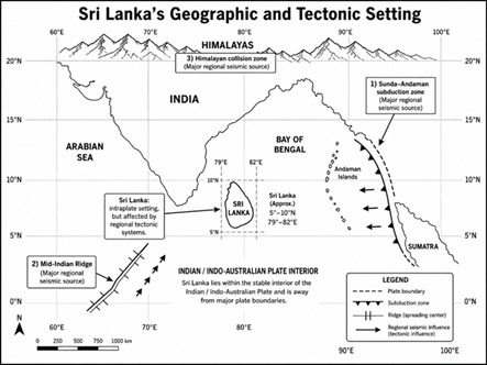
Figure 01- Geographical and Tectonic Position in Sri Lanka
Q: Has Sri Lanka actually felt earthquakes?
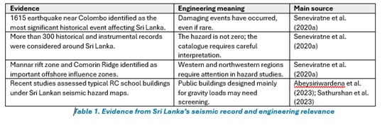
Yes. Historical and instrumental studies show that earthquakes have occurred in Sri Lanka and in the surrounding oceanic region. Seneviratne et al. 2020 analyzed more than 300 earthquake records around Sri Lanka and identified the 1615 earthquake near Colombo as the most significant historical event that affected the island. Their study also highlighted the failed Mannar rift zone and the Comorin Ridge as important offshore influences. The key message is not that Sri Lanka is a high-seismic country, but that it is not an earthquake free country.high-seismic country, but that it is not an earthquake free country.
Q: What does recent research say about present hazard levels?
Recent Sri Lanka focused studies describe the island as a low to moderate seismic region rather than an earthquake free area. Uduweriya et al. (2020) applied probabilistic seismic hazard assessment and reported bedrock level peak ground acceleration values that were highest along the western coastal zone, and are generally in the range of 0.05 g to 0.10 g, with an approximate value of 0.10 g for Colombo. Moreover, they have proposed a macro seismic zonation for Sri Lanka using two broad PGA zones, 0.05 g and 0.10 g, depending on location and importance of the structure.
These values may appear to be small when compared with high seismic countries. However, these are not negligible for structures? that were designed only for gravity and wind loads, with little ductile detailing. Hence recent vulnerability studies have focused on school buildings and masonry infilled reinforced concrete frames in Sri Lanka. Abeysiriwardena et al. (2023) emphasized that schools and hospitals require seismic risk assessment even in regions of low seismicity, while Sathurshan et al. (2023) showed that masonry infill irregularities can introduce short-column and soft storey vulnerabilities.
Q. How do researchers analyze the seismic threat: DSHA, PSHA and numerical methods?
Deterministic Seismic Hazard Analysis (DSHA) considers a credible controlling earthquake scenario and estimates the ground motion expected at a location. It is useful when engineers need to understand a worst credible scenario for critical infrastructure. Probabilistic Seismic Hazard Analysis (PSHA) considers many possible earthquakes, their recurrence rates, distances and uncertainties. Its main output is a hazard curve, from which ground motions for selected return periods can be obtained. In many design frameworks, the 475 year return period, corresponding approximately to 10% probability of exceedance in 50 years, is commonly used as a reference design level.
For Sri Lanka, PSHA is especially useful because the earthquake record is limited and uncertain. It allows available historical and instrumental data to be combined with regional source models and ground-motion prediction equations. However, PSHA alone is not the whole story. Local soil conditions can change the motion significantly between bedrock and the ground surface. Therefore, numerical site-response analyses, including finite difference modelling such as FLAC, are important for soft soil cities. These studies help to generate site-specific response spectra, especially for urban areas where medium-rise and highrise buildings may be sensitive to amplified periods of motion.
Q: What should practicing engineers do now?
For ordinary buildings, engineers should first understand the importance and consequence of failure. For public buildings, schools, hospitals, bridges, dams, emergency facilities and major commercial buildings, seismic action should be considered at least as part of a preliminary risk check. The design team should identify the ground conditions of the site, check whether the structure has adequate lateral load paths, examine vertical and plan irregularities, and pay attention to detailing, that improves ductility and prevents brittle failure.
Existing buildings need a practical screening approach. Many reinforced concrete buildings in Sri Lanka constitute unreinforced masonry infill walls. These walls may increase initial stiffness, but irregular arrangements can create short columns, torsion, soft storeys and brittle damage mechanisms. Rapid visual screening, followed by detailed assessment where necessary, is a realistic way to prioritize vulnerable schools, hospitals and older public buildings (Sathurshan et al., 2023).
Monitoring is also essential. Seismic design parameters become more reliable when they are supported by comprehensive data. Haberland et al. (2025) reported results from the first island-wide temporary broadband seismic network in Sri Lanka, involving 30 temporary stations and three permanent stations. Their work demonstrated that local seismicity can be identified with denser observations, and it supports the need for stronger national monitoring coverage and more open engineering data.
Q: What should an engineer check before ignoring seismic action?
Before the probability of a seismic action is dismissed, engineer should ask few practical questions: Is the building important for public safety or emergency response? Is it a school, hospital, bridge, dam, public building or Highrise structure? Is the site underlain by soft ground? Are there plan or vertical irregularities? Does the building have a clear lateral load path? Are columns, beams and joints detailed to avoid brittle failure? For existing buildings, masonry infill walls, short columns, open ground floors, heavy roofs and poor reinforcement detailing deserve special attention. These features can convert moderate shaking into serious damage.
Q: Does the 2004 tsunami mean Sri Lanka will experience strong earthquake shaking?
Not directly. The 2004 disaster was mainly a tsunami impact in Sri Lanka, not a case of severe local ground shaking. However, it is still highly relevant to engineers because it proved that earthquake related hazards from the Indian Ocean can affect Sri Lanka at national scale. Rossetto et al. (2007) reported the triggering Sumatra earthquake as Mw 9.3 and documented the damage and lifeline impacts in Sri Lanka and Thailand. The lesson is that engineering risk should not be limited to what happens inside the island; offshore sources, coastal exposure and infrastructure vulnerability must also be considered.
Q: What are the main knowledge gaps?
Three gaps are especially important. First, the historical earthquake catalogue is useful but incomplete; older events may have uncertain locations, depths and magnitudes. Second, Sri Lanka’s paleoseismic record is still poorly developed, and hence rare events that occurred before written records may not be fully understood. Third, permanent monitoring coverage has historically been sparse. Haberland et al. (2025) showed that denser island wide observations can identify local events more clearly and can separate natural earthquakes from. non tectonic earth movements. These gaps do not mean engineers should overestimate the hazard, but they do mean that design decisions should be made with caution.
Closing message: what is the practical lesson?
Sri Lanka should not be presented as a high-seismic country, but it should also not be treated as earthquake-free as well. The available evidence points to a low-to-moderate seismic environment influenced by offshore sources, intraplate activity and incomplete historical records. For engineers, the lesson is simple: do not design with fear, but do not design in ignorance. Better monitoring, updated seismic hazard maps, site-specific response studies and appropriate lateral detailing can reduce future losses. Seismic awareness should become part of professional engineering practice in Sri Lanka, particularly for important and vulnerable structures.
- Abeysiriwardena, T. M., Wijesundara, K. K., & Nascimbene, R. (2023). Seismic risk assessment of typical reinforced concrete frame school buildings in Sri Lanka. Buildings, 13(10), 2662. ttps://doi.org/10.3390/buildings13102662
- CEN. (2004). EN 1998-1:2004 Eurocode 8: Design of structures for earthquake resistance - Part 1: General rules, seismic actions and rules for buildings. European Committee for Standardization.
- Chen, W. F., & Lui, E. M. (Eds.). (2005). Earthquake engineering for structural design. CRC Press.
- Department of Census and Statistics Sri Lanka. (2021). Area and climate. Government of Sri Lanka.
- Dissanayake, C. B. (2005). A new plate boundary near Sri Lanka: Implications for future geohazards. Journal of the National Science Foundation of Sri Lanka, 33(1), 5-8. https://doi.org/10.4038/jnsfsr.v33i1.2361
- Gamage, P., & Venkatesan, S. (2019). Evaluation of seismic hazard in low to moderate seismic regions, Sri Lanka - A case study. Journal of Seismology, 23, 579-611. https://doi.org/10.1007/s10950-019-09824-3
- Haberland, C., Seneviratne, M., Ryberg, T., & others. (2025). Seismotectonics of Sri Lanka - insights from the first island-wide temporary network. Earth, Planets and Space, 77, 111. https://doi.org/10.1186/s40623-025-02250-5
- Rossetto, T., Peiris, N., Pomonis, A., Wilkinson, S. M., Del Re, D., Koo, R., & Gallocher, S. (2007). The Indian Ocean tsunami of December 26, 2004: Observations in Sri Lanka and Thailand. Natural Hazards, 42(1), 105-124. https://doi.org/10.1007/s11069-006-9064-3
- Sathurshan, M., Thamboo, J., Mallikarachchi, C., Wijesundara, K., & Dias, P. (2023). Rapid seismic visual screen method for masonry infilled reinforced concrete framed buildings: Application to typical Sri Lankan school buildings. International Journal of Disaster Risk Reduction, 92, 103738. https://doi.org/10.1016/j.ijdrr.2023.103738
- Seneviratne, H. N., Perera, L. R. K., Wijesundara, K. K., Dananjaya, R. M. S., & Jayawardena, U. de S. (2020a). Seismicity around Sri Lanka from historical records and its engineering implications. Engineer: Journal of the Institution of Engineers, Sri Lanka, 53(2), 47-52. https://doi.org/10.4038/engineer.v53i2.7412
- Seneviratne, H. N., Wijesundara, K. K., Perera, L. R. K., & Dissanayake, P. B. R. (2020b). A macro seismic hazard zonation for Sri Lanka. Engineer: Journal of the Institution of Engineers, Sri Lanka, 53(3), 37-44.
- U.S. Geological Survey. (2018). A possible cause of earthquakes in the continental interior. U.S. Geological Survey.
- U.S. Geological Survey. (n.d.-a). Earthquake magnitude, energy release, and shaking intensity. U.S. Geological Survey.
- U.S. Geological Survey. (n.d.-b). Determining the depth of an earthquake. U.S. Geological Survey.
- Uduweriya, S. B., Wijesundara, K. K., Dissanayake, P. B. R., Susantha, K. A. S., & Seneviratne, H. N. (2020). Seismic response of Sri Lanka using PSHA technique. Engineer: Journal of the Institution of Engineers, Sri Lanka, 53(2), 39-45. https://doi.org/10.4038/engineer.v53i2.7411
 Dr. P. Dhammika Dharmaratne
Assistant Professor / Structural and Geotechnical Engineer,
PhD(UoM), B.Sc.Eng(Hons), MEng(Struct.Eng.). PG Dip(Geo.Eng.),
PG Dip(Const.Mgt.). C.Eng., FIE(SL). Int PEng, MSSE(SL), M Cons E(SL).
Department of Civil Engineering,
Faculty of Engineering,
Sri Lanka Institute of Information Technology,
Malabe,
Dr. P. Dhammika Dharmaratne
Assistant Professor / Structural and Geotechnical Engineer,
PhD(UoM), B.Sc.Eng(Hons), MEng(Struct.Eng.). PG Dip(Geo.Eng.),
PG Dip(Const.Mgt.). C.Eng., FIE(SL). Int PEng, MSSE(SL), M Cons E(SL).
Department of Civil Engineering,
Faculty of Engineering,
Sri Lanka Institute of Information Technology,
Malabe,